He swore at them in French and broken English just before three shots rang out. It was the day after Christmas in 1894 when Francois Jean Rochas, simply known as “Frenchy”, died in his little rock cabin at the mouth of Dog Canyon where present day Oliver Lee State Park is located near Alamogordo, New Mexico.
 |
| "Frenchy's" cabin |
I’m here on a cold clear morning, where the temperature is in the mid teens, ready to run the canyon and then traverse the precipitous “eyebrow” trail that will take me across and up the Sacramento Escarpment in the Lincoln National Forest. The Dog Canyon National Recreation Trail is 5.5 miles (one way) with over 3000 ft of elevation gain so I better get a move on.
A series of steep switchbacks greets me at first, but then the trail meanders gently along the side of the gorge. I get tremendous views of the the shaded canyon that carves through solid rock and then the sun begins to illuminate the many colored cliff walls that surround the area. Since there is little wind today, I’m able to keep warm despite the low temperature.
Soon I’m high enough to get a good view of the Tularosa Basin below where Frenchy became a squatter in the early eighties. In his book, Tularosa: Last of the Frontier West, C.L. Sonnichsen describes Frenchy as the bravest man in New Mexico because he set up his cattle ranching operation in hostile Apache country where Texas cattlemen coveted the best supply of water in all the land. The curmudgeonly hermit paid no attention to warnings from others and lived a solitary life raising livestock and irrigating his vineyard and orchard from the pristine waters that flowed through Dog Canyon.
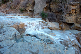
Running the trail and thinking about the settlers of this area makes the time pass quickly. I curve around through several small side canyons and climb a rock staircase (nice of them to build that) and eventually end up in a wide flat meadow. The packed dirt path makes for easy running before I reach a rock cabin ruin beside a small frozen stream. The cabin was used by early ranchers when they drove their cows up from the basin to grazing lands high in the mountains.
 |
| Fairchild Cabin |
I stop for a short break and to asses this so called “eyebrow” that I have to cross. I can hear voices in the distance and then look up to see several hikers climbing up to the bench. I watch as they begin the traverse only to see mere specks amongst towering cliffs above and below.
 |
| Hikers on the eyebrow |
Sonnichsen describes the trail and stream as, “...a precarious thread of pathway which clings to the cliffs and winds among the rocks until it emerges on the pine-clad summit; and for the little river of water which skips and sings among the boulders, filling one rock basin after another until the desert below licks up the last drop.”
A short steep hill behind the cabin takes me up to the escarpment where I begin to run again careful not to fall lest I end up in the canyon far below. This is the part of the route where Apaches were known to ambush intruders including U.S. Cavalry who suffered the raining down of boulders and arrows from above.
After some time I come to a natural amphitheater in the cliff and stop to marvel. Flat pews terrace upwards in neatly curving rows and I almost expect a park ranger to emerge in a neatly pressed uniform to give a fireside talk. Once across the eyebrow, I come to some slopes of grass, juniper, cactus and succulents where the trail is smooth but steep.
 |
| Amphitheater |
I continue to climb upward and then see a deer bounding into some cover. I stop to survey the area looking carefully for other wildlife and am fortunate enough to notice a large raptor; a red tailed hawk I believe, perched on some rocks. After he takes flight I keep running for a while longer and finally reach the terminus of the trail two hours after beginning my adventure.
I celebrate my arrival with some snacks and by snapping a few “selfies” beside the trailhead sign and then read a warning: Caution: Elevation Change To Oliver Lee State Park 3124 ft Return Hike Very Strenuous. Luckily for me, the arduous climb is over and my return trip will be mostly downhill.
The sun is warming the air just a little bit, but my face feels numb. Dried agave stalks and gnarled dead trees are surprisingly beautiful against the clear blue sky and I can see the gypsum dunes of White Sands National Monument in the distance.
When I reach the escarpment again, the trail turns into a series of high stairs that seem much steeper now than when I was coming up. My knees begin to rebel, but I’m able to descend the mountain, cross the eyebrow again and reach the little cabin.
As I finish the last leg of my run I ponder the brave man who “...loved solitude and found comfort in the savage scenery around his tiny rock hut, the burning desert beyond his door, the remote menace of the pale blue sky over his head.” (Sonnichsen)
Having already lived at Dog Canyon for 10 years, Frank Rochas was inquiring about the process of staking out his claim and acquiring water rights to the property when, according to Sonnichsen, three horsemen did him in. Many questions surrounding the circumstances remain unanswered and some think he took his own life, but I believe powerful cattle barons were responsible.
See you on the trail.


