I’ve been wanting to bag Guadalupe Peak (8751’), the highest in Texas, since I moved here in 2005. When my alarm goes off, I don’t hesitate to jump out of bed. I take a quick peek out my window and see that a light drizzle is falling. I’m sure it will dissipate shortly. After meeting at Ft Bliss, seven of us carpool to the park.
As we head east, the sun begins to color the sky pink and orange and the smell of wet creosote bush is in the air. I love the smell of desert in the morning. Soon El Capitan, a towering cliff face rising from the desert floor, comes into view as we drive past salt flats that were the subject of the El Paso Salt War in the 1800s. Once we arrive at the trailhead everything has dried out and the weather is cool for the beginning of our adventure.
Cholla, prickly pear, yucca and sotol along with juniper and Texas madrone trees make up much of the larger vegetation here. Rare Texas madrones with their tell tale smooth pinkish bark are usually only found in association with ashe juniper. In the fall, bark peels off and berries ripen to a bright red.
 |
| Texas Madrone, Juniper in background, cholla in foreground, sotol far right |
Pretty soon we travel along the side of a valley with sheer drop offs in spots and then come to a sign that reads, “Cliff riders dismount and lead”. I would not want to be riding a horse on this trail. We enjoy spectacular views of the other side of the valley and the desert in the distance.
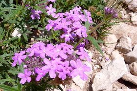
With all the recent rain, a plethora of wildflower varieties line the trail. Indian paintbrush, yellow primrose, verbena, red penstemon, blue flax, but my favorite are the canyon sage with their tiny bright blue blossoms.
 |
| Indian Paintbrush |
 |
| Verbena |
 |
| Penstemon |
 |
| Blue flax |
 |
| Canyon Sage |
We approach another section of narrow trail with a towering cliff on one side and a sheer drop-off on the other and then cross a footbridge that takes us over a gash in the ledge. We continue on and switchback up the mountain stopping occasionally to take in the view and to catch our breath. Some gnarled twisted dead trees dot the landscape of stunted shrubs and pine trees. The trail becomes very steep as we approach the peak and then the obscure metal pyramid marker comes into view.
 |
Everyone enjoys the fair weather and spectacular view. Thick clouds hang around El Capitan far below us and seem to build as we enjoy some snacks and camaraderie. The view of El Cap from up here is quite amazing with its mitten or Michigan shape, as some say. To me it looks like a lobster claw. What do you think?
Another highlight is a colony of ladybugs, technically convergent ladybird beetles, that have converged in thousands all over the vegetation. It is truly a spectacular sight and some of the bushes even look completely orange as if covered in berries.
After we take a few group photos, we head back down the mountain where we see several groups of hikers coming up. I’m glad we got an early start as the sun is starting to really heat things up. Before I know it, we are back at the parking lot, the return trip taking about half as long as the ascent.
On the way home, we stop for lunch at May’s Cafe in Cornudas, TX, population 5-6 (according to a sign at May’s). There is literally nothing out here but the cafe and it is easy to believe the population figures. According to the US Census, Hudspeth County has only 3337 people in a 4570 square mile area or .8 persons per sq. mile. Compare that to El Paso at over 2500 people per sq. mi. But I digress.
I know we are in for a treat when May brings the menus as they are written in colored Sharpie on brown paper bags. The iced tea is served in mason jars, Ball of course, and the speciality is the Cornudas burger (green chili and cheese). You just can’t beat a good burger after a hike to the highest point in Texas.
See you on the trail.


No comments:
Post a Comment