With the Franklin Mountains 50K Trail Run in just a few short months, I decided to put together a course preview for you. This year the race, in El Paso, TX, is part of the Altra US Skyrunner® Series meaning it must have a minimum amount of elevation gain per distance. Here are a few definitions from the International Skyrunning Federation to help you understand:
“SKYMARATHON® – minimum distance 30 km and under five hours (winner’s time). Minimum 2,000m vertical climb
ULTRA – Races over 50 km between five to twelve hours for the winner.
ULTRA SKYMARATHON® – Races that exceed the parameters of a SkyMarathon® by more than 5% with more than 2,500m vertical climb.” (2500 meters = 8200 feet)
 |
| 2016 Franklin Mt 50K Elevation Profile |
So yes, you will be doing a lot of climbing in this race. Around 8250 feet! I ran the course last spring when the weather was still cool and it took me 10 hours to complete. Keep in mind that I’m a mid to back of the pack ultramarathoner. I’m sure our elite and Flatiron runners from Colorado will be twice that fast looking fresh as daisies as they sprint across the finish line, although heat will be an issue this year. It’s the rest of you I’m worried about. If after reading this, you decide the 50K is too much for you, consider running one of the other distances that Trail Racing Over Texas is offering the weekend of 9-11 Sep, 2016 (5K, 10K, half marathon, King/Queen of the Mt). Hopefully this guide will help you survive the race and still have a good time. Isn’t that what our sport is all about?
 |
| Franklin Mountains State Park, El Paso, TX |
I’ve been training in the Franklins for seven years and spend many hours exploring the abundance of trails in the Franklin Mountains State Park. I’ve been to N. Franklin peak many times; sometimes twice in a day, ran 50 kilometers here on my 50th birthday and consider this, the nations largest urban wilderness park, my second home. Last year I volunteered with Team Red, White and Blue, a beneficiary of the race, at the Mundy’s aid station.
Before we get to the course description, here are a few tips:
- A little bit of common sense goes a long way.
- Wear sturdy cushioned shoes unless you are used to running over jagged rocks in minimalist footwear. (Last year a guy’s shoe blew out on the way down from N. Franklin Peak, so we wrapped duct tape around it and sent him on his way.)
- Trekking poles may be a good idea especially on treacherous descents.
- Train on rocky terrain with lots of hills if possible. Downhills are harder on joints and I always hear a lot of knee complaints. (Pack a brace if you are prone.)
- Altitude may be an issue if you are a lowlander. N. Franklin Peak is 7192’ elev.
- There is no shade, so protect your skin.
UV exposure increases about 4% for every 1000 ft gain in elevation. —Web MD
- Don’t go out too fast! Pace yourself and enjoy the mountain scenery. This is a beautiful park.
- Plan for a longer finishing time. If you think you are going to run it in 7 hours it will probably be 8-9.
- Wear a good hydration pack/vest that can carry at least 40oz of water if not more. It will most likely be hot and could take several hours to reach the next aid station.
- Rattlesnakes may be on the trail. They don’t always rattle so stay vigilant, give them a wide birth and leave them alone if you encounter one. (Chances of dying from a snakebite in the US is nearly zero.)
Did you know that you are nine times more likely to die from being struck by lightning than to die of a venomous snakebite? —UF Wildlife (Johnson Lab)
- September brings monsoon rains so thunderstorms are possible. Dry arroyos can turn into raging torrents. Seek higher ground. Common sense, right?

 |
| 2016 Franklin Mts 50K Course Map |
Start —Upper Sunset Trail (Mile 1-2)
The race begins with a climb and traverse of several rocky foothills that run parallel to the main Franklin range, although you will feel like you are making a significant climb. Remember, this is just a warm up for what’s coming later in your day. Trekking poles are a good idea in this race but I would get some rubber tips because you will be running over slabs of solid rock at times. A few spots on this trail will require you to climb rocky steps but most of it is single-track trail. Needless to say, prickly vegetation like shin dagger, Spanish bayonet, agave and cactus line most of our trails so be careful where you land when you fall. (Word on the trail is that you get bonus points for blood, puke and thorns.) In a little more than a mile you will descend and come through the main staging area and finish line. Too bad you still have over 30 miles to go.
What it looks like (click photos for larger view):


What it looks like (click photos for larger view):


 |
| Mike and Jorge gettin' it done! |
Schaeffer Shuffle/Lower Sunset Trail (Mile 2-6)
You will descend a hill that local runners affectionately refer to as “Big Bertha” and then turn right onto Schaeffer Shuffle trail. You will make another right when you reach the dry wash, but be sure to climb out on the trail to your left; otherwise you will be lost in the canyon racking up some bonus miles. Actually TROT does a great job of marking the course. The trail is smooth for a while, but then you begin a very steep climb where the path seems to disappear as you hike over crumbling perpendicular slivers of rock. You’ll then pick up a smooth section of trail for a short while. Now you run down a very precipitous, slippery path of crumbling rock and dirt. Fred Flintstone bowling balls fill the gutter you will run down so be careful. Did I mention that I rarely go on this trail because I find that it isn’t runnable? Be careful on this descent; in my view, one of the trickiest in the entire race. Once at the bottom, you’ll cross a dry arroyo and run a flat trail for a bit. You’ll enter the arroyo and then climb out on your left. Don’t miss this left or again, you will be lost in the ditch. Now it’s time to really run. You will reach a jeep road where you’ll turn right, cross another arroyo and run the Lower Sunset Trail (left) back to the staging area. This is a mostly smooth, but windy single-track trail with a bit of elevation gain.
 |
| Gordy Ainsleigh ran last year. |
The excellent trail marking was very appreciated. Even with my eyes glued to the trail in hope of avoiding further blood loss, there was never any doubt as to where to go.
—Gordy Ainsleigh
What it looks like:
 |
| "Big Bertha" |


 |
| OUCH! |


 |
| Lower Sunset Tr. |

Aztec Cave (Mile 6-8)
After hitting the main aid station, you’ll get a short break from climbing and then pick up the Aztec Cave trail. You’ll be able to see the shallow caves, your destination, by looking up at the mountain face. This one is mostly uphill, but there are a few short steep descents in and out of the drainage. The closer you get to the caves, the steeper the trail becomes and finally you reach some very high steps. Continue to the left of the first cave where you may need to use your hands to keep your balance. Stop inside the second cave to catch your breath, enjoy the view and take a selfie; you deserve it! Besides, the climbing isn’t over yet.
Once recovered, continue to the left of the cave on the slab of red, brown and gray rock where you will see footholds made of blobs of cement. Again, you may need your hands to climb up in a few places or use your trekking poles to keep your balance. Over to your left is a dirt trail that will take you the rest of the way up the mountain. This trail isn’t used much because it is quite precarious in places. Unless you are in first or last place, I would take my time on this part and stop to take in the view of the Rio Grande Valley in the distance. CAUTION: watch your right side for the next mile or so because there are a few exposed precipices where a slip could really ruin your day. You’ll climb down and out of some rocky gullies and then need your hands or poles again towards the end of this trail.
You will intersect the Mundy’s Gap Rd where you will turn right. This is a great place to make up lost time. Bomb down this stretch because it is the smoothest ride you’re going to have for a while. Be careful when you get to the narrow section with wooden timbers shoring up the trail. Heavy rains washed the road out several years ago so volunteers had to rebuild this section to make it passable. Your blistering pace will come to a screeching halt when you reach the bowling alley, a scree field descent with ankle breaking rocks. At the bottom you will come to the aid station.
What it looks like:
 |
| Aztec Caves |

 |
| Cool off here and snap a runfie |

 |
| Enjoy the view |


 |
| The bowling alley |
After leaving the parking lot, turn right and then look for a trail on your left. You will now ascend a new trail that was built by the legendary Robert Newman. The 80 year old retired school teacher singlehandedly built over 12 miles of trails in our state park. The mostly smooth narrow trail gently winds up the slope. After reaching a flat paragliding launch site you will take the higher route (not signed, look south). (Watch Mr Newman building this trail in the video.) You will climb at first and then run parallel with Agave Trail along the slope with a perilous drop-off on your left. You will cross several short scree fields with bad footing, descend to traverse a large scree field and then make a steep climb with high steps to West Cottonwood Spring. Rest on the bench and enjoy the shade under the huge cottonwood tree; it’s the last piece of shade you will have for the rest of the day.
Watch: Trailblazer Robert Newman (Texas Parks and Wildlife):
Continue to your left (NE) and climb a steep crumbly dirt slope up to the main ridge, turn left and run down the spine to Mundy’s Gap. Here you will get your first glimpse of the NE side of El Paso. You can make up some lost time as you run down Mundy’s Gap Rd to the aid station.
What it looks like:


What it looks like:


 |
| Approaching West Cottonwood Spring |
 |
| Down to Mundy's Gap |
North Franklin Peak (Mile 10-14)
Now the real fun begins. This is what you have been waiting for all morning; the last two miles and 1500 feet of elevation gain to the top of N. Franklin Peak (7192’). This section is an out and back or up and down if you will. From the aid station the footing is good until you climb over a rock slide area in a half mile. The trail is smooth again but makes a sharp switchback to the right that is very steep and full of rocks. After another switchback to the left, you will climb to a saddle with a sign that warns of unexploded ordnance. Don’t go that way! Take a short break, let your heart rate settle down and enjoy the view of the Castner Range, a former Army artillary range being considered for a national monument.
Continue to the right where you will soon go through an eroded gully where the road was washed out in floods of 2006. Once out of the ravine, a series of switchbacks takes you the rest of the way up the mountain. Each time you turn a switchback you will think you are almost to the summit, but this isn’t the case and it can wear on you psychologically if you let it. (From the saddle there are seven switchbacks.) Some sections are gradual and smooth enough to run if you are good, but at other times the trail turns into a rock garden full of knee gashers.
Finally you will top out with excellent views of Mexico, Texas and New Mexico. After high fiving your fellow runners and possibly puking, it will be time to run back down the mountain. Most accidents happen on the way down and I find that some sections take as long going down as coming up because they are so treacherous. In two miles you will return to the aid station.
Running an ultramarathon is 90 percent mental; the other 10 percent —that’s mental too. —Scott Jurek
What it looks like:


 |
| Leo gettin' up N. Franklin Peak. |
 |
| Knee gashers |
 |
| Looking North |
 |
| The view, S. Franklin Peak in the distance |
 |
| Photo: Myke Hermsmeyer/Trail Racing Over Texas |
Mundy’s Gap to Tin Mines (Mile 14-16)
After freshening up at the aid station you will run down a dirt road, but there are a few rough rocky sections. Nevertheless you should be able to make up more lost time if your quads aren’t shot yet. At the bottom you will come to some abandoned tin mines on your left. The only tin mining operation in the US from 1909-1915 was, unfortunately not successful. You will also see the ruin of a concrete structure on your right. Here you will reach Old Tin Mine road to your right, but will keep going straight to pick up one of my favorite trails in the entire park, the Scenic Road.
What it looks like:


 |
| Tin Mines (upper left) and concrete ruin |
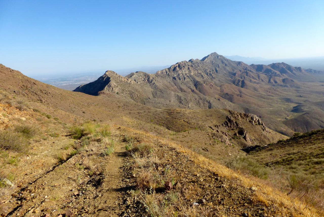
Scenic Road/Sotol Forest (Miles 16-19)
Aside from a few hills, Scenic Road is the most runnable section. The trail follows the contour of the mountain and you’ll have some great views of NE El Paso and perhaps the Bowen Ranch Roundhouse in the distance. Around mile 17.5 you will make a left turn onto Sotol Forest Trail. Sotol is the jagged succulent with one inch wide serrated leaves that hang down. Many will have a tall feathery plume like stalk rising from the center. This red sandy trail becomes very twisty at the end, but then you will come to some smooth rounded goblin like sandstone rocks all over the trail to keep you on your toes. Remember, when you reach Yellow-green Rock, you are only one F-bomb and a “JESUS CHRIST!” away from the aid station, which for me, is about ten minutes.
What it looks like:

 |
| Smooth sailing for a while. |


 | ||
The Roundhouse can be seen in the distance.
|

 |
| Yellow-green Rock |
Newman Trail/Northern Pass (Miles 19-26)
If anyone told you that all the climbing was behind you after N. Franklin Peak, they lied. You will now ascend Newman Trail, named for the 80 year old man who built it. If an 80 year old can singlehandedly build a trail, certainly you can run it, right? While not nearly as bad as the other mountains you’ve run today, this one should be respected. The good news is that it is mostly smooth. There are some nice barrel cactus on this trail when you get higher on the mountain. You will reach a pass at mile 20.5 and then descend gradually where you will be able to pick up your pace. Newman’s trail dumps you out on a ranch road where you will pick up another trail that takes you along the contour of the mountain again.
Soon the trail becomes red and has jagged rocks protruding up out of the ground. The heel of your shoe can easily get stuck between some of these so take it easy; the trail smooths out in a few minutes anyway. At around mile 23 Hitt Canyon comes into view and then you will see the Northern Pass that takes you back to the west side of the Franklins. Unfortunately, a deep canyon lies in the way, so you will run along the rim to the head of the drainage. The boulder strewn gully is very beautiful; hemmed in by high peaks and the trail makes some fun twists and turns around several smaller arroyos.
Just before arriving at the gap you will run over some sharp slabs of bedrock that can do a number on your shoes if they aren’t sturdy. Once at the Northern Pass you will descend a series of switchbacks where the trail is quite technical due to some rocky outcrops. You’ll transition onto a dirt road that will take you to the last aid station.
What it looks like:


 |
| The view from the top of Newman's Trail looking north. |
 |
| Twisty single-track |
 |
| Hitt Canyon |

 |
| View from Northern Pass looking west. |
 |
| Coming down from N. Pass. |

Middle of Nowhere (Miles 26-32)
The next stretch begins with a trip through a wide gravelly wash. You’ll see a trail marker with a #28 on it and will see more along the way with ascending numbers. (These are not mile markers.) Soon you’ll exit the wash via a marked trail on your right and follow a ranch road. This will drop back into a narrow ditch and exit on the other side. In a little more than a mile you’ll come to a deep cut between a slanted escarpment. Usually a breeze is blowing here so this is a good spot to take in the view.
The rest of the trail is mostly smooth, flat, straight and featureless. I rarely see anyone out here except vultures circling overhead waiting for me to drop. Welcome to The Middle of Nowhere, TX. This is the part of the course where you, depending on the type of person you are, begin to confess all your sins or try to sell your soul to the Devil. The heat is so intense and you are so exhausted that you just can’t wait to get this thing over with. You’ll eventually see Mammoth Rock in the distance, but you are still quite a few miles from the finish.
It’s so desolate and quiet that you may begin to see and hear things. Was that a rattlesnake? Mountain lion? Zombie? Dead yucca plants look like people. In fact, I had an intelligent conversation with one once. Her name is Shaggy. The trail will take you in and out of a few arroyos and you’ll go past a barbed wire fence. You’ll hit a technical section with slabs of sharp rock underfoot and then cross a wide dry wash where you’ll turn right on the dirt park road that you ran this morning. Run down the road and through the arroyo and take the Lower Sunset Trail up to the finish line to receive your well deserved bling.
What it looks like:


**That bug on the sign is a tarantula hawk wasp. They paralyze a tarantula, drag it into their den and deposit an egg on the abdomen. The larva then feeds on the live tarantula. The female's sting is said to be the most painful of any insect, but don't worry; they don't sting humans unless provoked.
...[scientists'] recommendation—and this was actually in a peer-reviewed journal—was to just lie down and start screaming, because few if any people could maintain verbal and physical coordination after getting stung by one of these things. You’re likely to just run off and hurt yourself. So just lie down and start yelling.
—Ben Hutchins, biologist (Texas Parks and Wildlife)
 |
| Tarantula hawk dragging her paralyzed prey. |

 |
| Slanted escarpment |
 |
| Mammoth Rock in the distance |
 |
| You might see Shaggy on the trail. She's friendly. |
For the shorter distance races read the Schaeffer Shuffel and Upper Sunset sections. This will give you a good idea of what to expect. Look at maps on geobetty.com or pick up a free GeoBetty map from a local running/cycling shop if you plan to run parts of the course in training. The Schaeffer Shuffle and Newman trails are not shown on the online version of the map.The portion from Aztec Cave to Mundy's Gap Rd is not on either map. Here is another course map on Gmap- pedometer. (It takes a while to load).
Trail Racing Over Texas does a great job of putting on races and this is sure to be an exciting year at the Franklin Mountains Trail Runs. God willing and the arroyo don’t run, I’ll see all your smiling faces at the Mundy’s Gap aid station.
 |
| Lucy, my personal trainer. |
See you on the trail.
Thanks Greg, super helpful! Thank you for your time and effort on this truly appreciated. See you out there!
ReplyDeleteThanks Greg, super helpful! Thank you for your time and effort on this truly appreciated. See you out there!
ReplyDeleteThanks for reading, Flat. Good luck in the race!
DeleteAwesome write up. I'm both excited and terrified. :)
ReplyDeleteYou can do it, Amy Jo. Have a great race!
DeleteThank you! This is the second time I have read it and this is helpful! :) This helped me get to check out the first part up through the Aztec Caves a couple of weekends ago.
ReplyDeleteGlad it helped. Thanks for reading!
DeleteI really enjoyed reading this article. This will help me and my friends be prepared for it! This will be our first time tackling this kind of terrain and we are super excited!!!
ReplyDeleteAwesome! You are going to love it here. Good luck in your race!
DeleteGreat info thanks
ReplyDeleteThanks for the elaborate blog. It is very helpful for amateur runners.
ReplyDeleteThanks for reading Mave!
Delete