Well, if you haven’t heard, New Mexico is pretty much on fire with two of the largest wildfires in the state’s history still burning. Some monsoon rains moved in a few weeks ago though, which has considerably helped the situation. The concern now is flooding, erosion and mudslides in the burn areas.
Because of this, my spring race, the Jemez Mountains 50 Miler, was cancelled this year due to forest closures. This summer, we had planned a trip to Colorado because my kid was going to music camp at the Beaver Creek Ski Resort near Vail, CO. What's really amazing though, is that my wife said I could run and hike during the day while they attended her music classes. Well, that sounded like a grand idea to me!
 |
| Beaver Creek, CO |
My first worry started when we pulled up to the upscale gated luxury village that was developed by oil tycoons in the 80s. I thought to myself, there’s no way they are going to let the likes of me and my 15 year old truck into a place like this. To me, luxury accommodations are a campground with a pit toilet. Five star camping includes a public bathroom with running water. (Glamping!) Anyway, we somehow made it past the security gate and checked into our fancy place which had everything under the sun including the kitchen sink!

The trails were just a short walk from the front door so I was pretty much in heaven all week. The first day I ran through the ski village and hit the Turquoise Lake trail, a 16 mile round trip to several high alpine lakes. I ran along Beaver Creek which was roaring and churning its way down the mountain from all the snow melt. The trail was steep in places and I climbed up from the creek bed where I ran along a precipitous drop off to the roiling stream below.


 |
| Mount of the Holy Cross (1873 W.H. Jackson) |

…an area where the earth and its community of life are untrammeled by man, where man himself is a visitor who does not remain. An area of wilderness is further defined to mean in this Act an area of undeveloped Federal land retaining its primeval character…
— Wilderness Act of 1964
 |
| American globeflower |
 |
| Beaver Lake |

 |
| Lower Turquoise Lake |

 |
| American Globeflower |
 |
| Mountain marsh marigold |
I reached the Upper Turquoise lake at 11,300’ elevation which positively had a turquoise hue to it. I started to take some pictures and then I heard a guy yell out, “Hello there!” I said, “Hello, I finally found the lake by following my nose. Is this where the taco truck is, I’m kind of hungry!” He laughed and then I asked him if that was his campfire I smelled. He said “Yes, I’m getting ready to head out soon.” We chatted for a few minutes and then I explored the banks of the lake taking in the view.
 |
| Upper Turquoise Lake |

The second day of my trip, I took off through the ski area trail system and skirted the village. I climbed up on the Aspen Glade Trail where I had great views of the village nestled in the valley below. I reached a windy dirt road that took me higher, where I reached Paulie’s Plunge Trail which leads down the mountain towards the community of Eagle Vail. A Forest Service sign warned of a trail closure until Jun 20th to reduce stress on calving elk. I looked at my phone for the date and realized that today was opening day of hiking season in Colorado —Jun 21st, summer solstice!


 |
| Stone Creek, Paulie's Plunge Trail |
 |
| Western wild rose bud |
Paulie's Plunge Stone Creek:
The third day, I ran the Eastern Hillside Trail which is mostly an equestrian route for guided horseback riders. I wasn’t sure if I was supposed to be on it or not, but figured I’d get out of the way if the horse train came along. I had a hard time following the trail in places because there were a lot of social trails coming up from housing areas below. Again, I used my map app to stay on course.
 |
| Wild blue flax |
 |
| Scarlet gilia |
This trail was really beautiful taking me through open areas dominated by sage brush. The wildflowers were abundant so I had a hard time running for want of stopping to take photos. I must have photographed a dozen different varieties of blooms. I had great views of the village below and the lush green ski slopes on the other side of the valley. There were a few short steep climbs, but mostly I ran along the contour of the mountain slopes eventually reaching grassy meadows and groves of aspen.
 |
| Umbrella Desert Buckwheat |
 |
| Blue and white lupine |
I made it back to the ski area boundary where I took Allie’s Way and Overlook Trails to the other side of the valley passing several ski slopes on the way. A mountain biker was coming the other way and stopped to alert me of a bear cub that he saw higher on the mountain. “If there’s a cub then you know theres a momma!”, he warned. Well I wasn’t going that high on the mountain on this particular morning, but I made sure to make a lot of noise with my trekking poles.
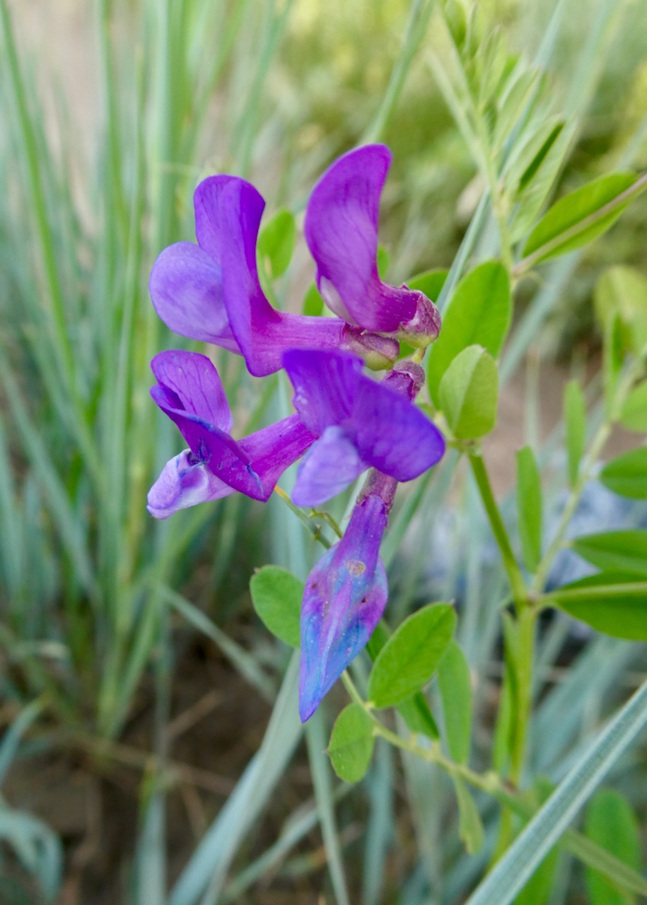 |
| Vetch |
I had been running with my bear bell attached to my pack and had been carrying bear spray all week, just in case. Making noise is one easy thing we can do to help warn bears that we’re entering their territory which can help keep them safe. Wait, WHAT! That’s right; when a bear attacks a human they are hunted by wildlife officials so it is always better to avoid any bear encounters. Unfortunately, a woman was killed and partially eaten last year near Durango, CO according to the Denver Post.
“Once a bear injures or consumes humans, we will not risk the chance that this could happen to someone else…We humanely euthanize that bear because of the severity of the incident.” —CPW Southwest Region manager Cory Chick
 |
| Colorado blue columbine |
I continued on my run and was spooked by any noises that I heard. A jet overhead sounded just like a bear growling. I continued to hear another unidentified noise over and over again. Was it a bear huffing or was I just hearing things? Eventually I figured out that it was the ski lift overhead that was taking tourists up the mountain to the Spruce Saddle Lodge Restaurant. I was certainly on edge, but made it past the ski slopes and back into the forest. Soon I heard a rustling in the leaves and brush; sure it was a bear ready to attack me. I stopped in my tracks and then a large chicken sized bird popped out. She was grey and mottled with tinges of white with a sort of orange eyebrow. I knew this bird as a Dusky grouse because I had seen them in the Jemez Mountains in New Mexico and also in the Big Horns in Wyoming.
 |
| Dusky grouse |
Eventually I picked up Dally ski road where I heard a high pitched chirp that sounded like a bird. I knew better though, and started looking around for a rodent known as a “whistle pig”. I saw a large pile of boulders and figured there was a Yellow-bellied marmot giving his warning call that a predator was in the vicinity. Sure enough, I soon spotted the designated lookout, who was perched atop the rock pile warning all the others in the colony of my presence. I irritated this poor creature by taking some photos and video and then took off down the road. I finished this nine mile run by cruising into the village center where tourists and shoppers were strolling about.


I navigated my way up the spine of the rocky outcrop losing the trail in a few places, but never straying too far off course. Eventually I ran through some aspen forest and then popped out into a high meadow where I climbed up to the developed ski area at 10,200’ elevation. This is where tourists are dropped off after taking the main express ski lift up to the Spruce Saddle Restaurant. While it took me an hour and forty minutes to reach this spot, they arrive in about 8-9 minutes. During ski season, they can then pick up another lift that takes them even higher on the mountain. For hikers, a dirt road known as PHQ Hillclimb leads to the top.

The area was completely deserted when I arrived before 8:00am and the lift wasn’t running yet. I had the whole place to myself. I started up this road with ski slopes all around me and saw what looked like a large mammal far in the distance beside the road. The sun was low in front of me so I couldn't see very well. I watched for a while and there was no movement, so I thought maybe it was just a snow making machine or some other ironmongery for maintaining the slopes or whatnot.
 |
| Spruce Saddle Lodge and Restaurant |
Soon this animal started to move though, and was slowly lumbering along the side of the road towards me. Sure enough it was a bear; luckily pretty far away. It stopped and we watched each other for a minute where it didn’t seem too bothered by my presence. I backed up and moved up onto a ski slope to give it plenty of space. I unclipped the safety thingy on my bear spray canister and just waited there while snapping a few pictures. The bear continued towards me for a bit and then veered off the road into a small patch of woods. I didn’t feel like I was in any danger so I went downslope on the opposite side of the road of the bear and slowly made my way past it. I didn’t see it again and figured I was in the clear. I decided to continue to the top of the mountain knowing that the lift would be running soon and maintenance trucks would be driving up the road. I believe my presence was the bear’s cue to go to bed.
 |
| Hello bear! |
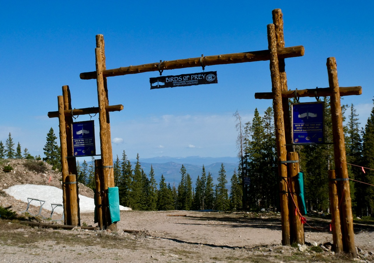
I continued on the gradual uphill climb and was even able to run parts of it. I had great views of Avon, CO below and the snow streaked Gore mountain chain in the distance. A few work trucks passed me along the way. In about an hour I made it to the top of the Birds of Prey and Raptor ski runs, the latter being a World Cup downhill course. There was a ski patrol shack flying an American flag with a patio and picnic table so I stopped to eat a snack and put on sunscreen. After taking in the view I took off running down the road. I made it back to Spruce Saddle Lodge where I went inside to fill up my water bottles.
 |
I wanted to get in 20 miles and was only at mile 9, so I decided to take the Royal Elk Trail, which cuts across the ski slopes, to Turquoise Lake Trail. I climbed up to Beaver Lake and sat by the shore and took a snack break. I was pretty hot and beat by this point, but luckily most my trip home would be downhill. I got some more miles on Village-to-Village Trail and then traversed the ski slopes again to finish on Aspen Glade. I finished in over six hours with 4300’ of ascent.
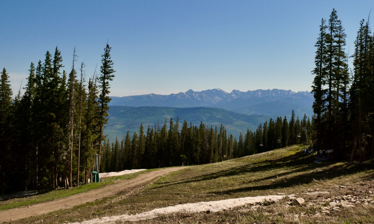 |
| Gore range |
 |
| Royal Elk Trail |
By the fifth day at Beaver Creek I was worn out from running 57 miles in four straight days with almost 13,000’ of elevation gain! I needed a rest, but just couldn’t do it, so I set out for a nice easy run on the Elkhorn Trail. This trail leads down the hill to the town of Avon along the Eagle River. I started on the Lost Buck trail where I watched a deer for a short while and then passed by the backyards of some upscale homes. I crossed a bridge spanning a paved road and soon entered aspen forest with lush ferns lining the trail. It had rained the night before so the forest had a nice smell and the morning was cool. I only went about three miles before turning around.

On the way back I heard the chirp of a marmot and watch it scurry into a drainage pipe that went under the road. I went to the other end of the pipe and waited patiently to see if it would emerge if I was patient enough. He was at the end of the pipe watching my every move knowing that he was safe. I tried to get a picture but grass was growing in front of the pipe preventing me from getting a good shot. I made it home in no time and spent the rest of the day resting.
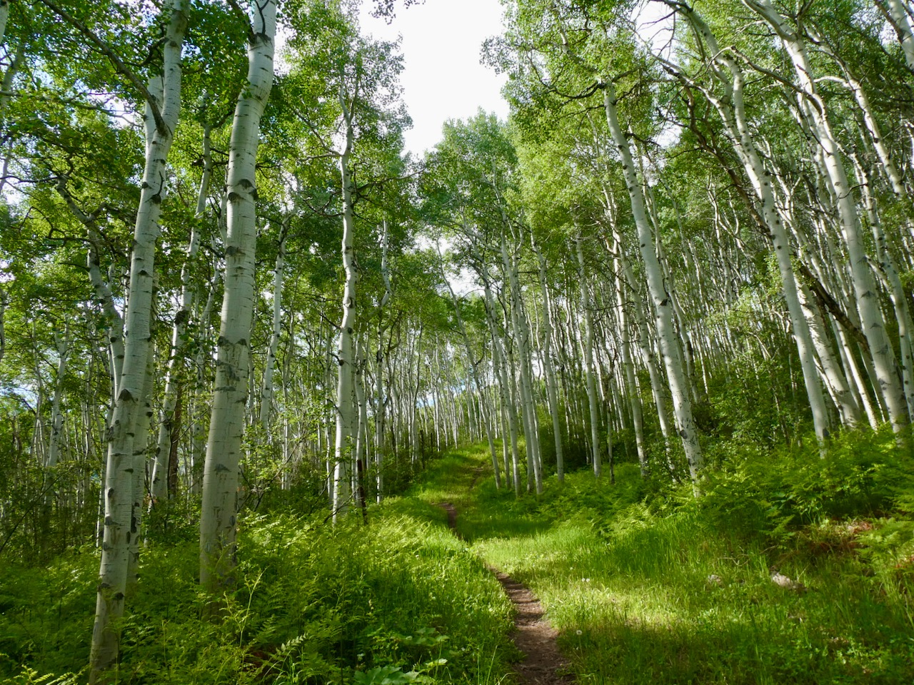 |
| Elkhorn Trail |
I went for a cup of coffee and walked around town when a storm suddenly rolled in. I ducked into a shop to stay dry and realized that I had made the mistake of entering a high end art gallery. I was a bit nervous and made sure not to inadvertently knock over any Gib Singleton western or religious sculptures. There were all manner of breakable glass vases and other delicate modern artworks in this place.

I was particularly drawn to some wall sized framed David Yarrow western themed and wildlife photographs including one with six frosty bison running through snow towards the viewer. I was interested until I saw the $69,000 price tag! Another giant picture featured the real "Wolf of Wall Street" (whoever that is) and was complete with a live wolf in the center surrounded by super models and an office filled with stock brokers; $100 bills and confetti raining down. To his credit, David Yarrow's passion is not only photography, but philanthropy and conservation as well. His photographs have raised millions for charity in recent years.
Read: ‘The Wolf of Wall Street’ photo, with the real Jordan Belfort, sells for $200,000
Well, the storm abated shortly and I was able to get out of there unscathed; without having to pay for anything. Beaver Creek Resort is not only a great place to run, hike and ski, but also a good place to pick up a Gib Singleton “Wildcatters at Spindletop” sculpture for that oil tycoon on your Christmas shopping list.
See you on the Trail
No comments:
Post a Comment