About my blog

Welcome to my trail running site. I enjoy being on the trail where I can take in nature and clear my mind. I prefer running in the mountains, but anywhere rural will do. In years past, I have completed four 100 mile trail races and many other ultramarathons. I spend countless hours running in the Franklin Mountains and the surrounding desert in far West Texas, which I call my church. My little Mexican hairless dog, Taz tags along sometimes. I am slowing down in my old age and am mostly running 50K trail races these days.
Showing posts with label Marathon. Show all posts

Sunday, May 19, 2024

Jemez Mountain Trail 50K 2024

 Last weekend I ran the Jemez Mountain Trail 50K in Los Alamos, NM, where scenes from the movie Oppenheimer were filmed. Sadly, I have not seen the flick yet, but have read a lot about the Manhattan Project and am intrigued by physics and nuclear energy. I’m amazed by the fact that within 2-3 years scientists and others working in Los Alamos, were able to create and detonate “The Gadget”, “Little Boy” and “Fat Man”, the first three nuclear bombs. Although I’m no fan of nuclear weapons, war or other human atrocities, I find the ingenuity, determination and spirit of the men and women who worked on this project to be very inspiring. 


The National Park Service recently established the Manhattan Project National Historical Park.

Established in 2015, the Manhattan Project National Historical Park preserves and interprets the nationally significant historic sites, stories, and legacies associated with the top-secret race to develop atomic weapons during World War II. —USNPS


Many of the sites in the park aren’t open to the public yet, but I believe there are guided tours for some of them. 


The real gem of this area though, and reason it was chosen, is the surrounding mountains, canyons and mesas of this remote area of northern New Mexico. The abundant scenery and peace and quiet in the Santa Fe National Forest creates a serene atmosphere, perfect for hiking and running.  
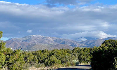
Jemez Mountains as seen from town

This was my 10th time running this race with an equal amount of varied experiences to include altitude sickness, weather related adventures and much pain and suffering resulting in five 50 mile finishes, three 50K finishes and a couple DNFs. Ten years ago when I was here, a freak snow storm closed the course midway through the race. Some runners were caught off guard, especially near the 10,400’ summit, leading to hypothermia so race officials are very strict about requiring runners to carry mandatory rain gear, hat and gloves. The Jemez mountains are remote and threatening weather can pop up at any time of the year.


Read my post: Running Adventure Gone Wrong

Text alert system
I had planned on carrying my lightweight rain shell and an extra thermal layer in my hydration vest, however the weather was calling for rain showers and afternoon thunderstorms with a high (in town) of around mid 50s. At the last minute, I opted to wear a heavier lined rain jacket that I would tie around my waist since it was too big to fit into my pack. 

Well, we started the race from the Los Alamos Sheriff’s Posse Shack, on a cool foggy morning with no precipitation. However, within the first mile it started to spit rain mixed with sleet so I put on my rain jacket and zipped up. I had a lot of energy and kept up a good pace with a train of runners in front and behind me. The beginning of the course descends into a canyon between several mesas as Los Alamos was built on the slope of a super volcano with alluvial fans flanking the east side. The accordion-like folds of the fan create flat-top mesas with steep rocky cliffs into narrow canyons below; perfect terrain for hiding a top secret project.

Valle Caldera, alluvial fans and Los Alamos
We ran on smooth packed dirt trails lined with tall pine trees and passed by high pock marked cliffs before picking up the Guaje Ridge. The temperature dropped the higher I climbed and a mix of rain, sleet and snow fell, off and on. I pulled out my trekking poles and kept a steady fast hike up the mountain where half burned trees were shrouded in a misty fog. The trail took many short twists and turns switch-backing up the ridge. 

After about 10 miles or so, my energy began to wane so I ate a small part of a sandwich and a few mandarins. Soon I became very drowsy and negative thoughts about completing the race entered my mind. The weather was very poor at this point and my hands were cold and numb from taking my gloves off to eat. The altitude was affecting me as well, because I was climbing up to around 9700’. I tried my best to simply focus on the present moment instead of worrying about the misery that may come later in the day. 

I reached the high point of the trail where I turned right onto a mostly descending forest road. Thick fog hindered my visibility and snow and ice were accumulating on the ground. I folded up my poles and attached them to my vest, and I started running down trying not to slip on an icy rock or patch if snow. I arrived at the Pipeline aid station where volunteers had a small wood stove burning to keep warm. I forced myself to eat an oatmeal bar even though I had difficulty opening the wrapper for my freezing fingers. Once my water bottles were filled, I took off down the road. The next stretch was mostly downhill or flat so I tried to run as fast as I could to make up lost time from the morning’s climb. My mood picked up somewhat on this part. 

Running into Pipeline aid station:


I made it into the ski lodge aid station which is almost half way, but sits at 9200’. Again, I forced myself to eat a few mandarins to fuel my system for the big climb ahead. In no time, I was out of there and followed orange flagging across the ski slopes picking up a trail that went straight up a black diamond ski slope. The climb was tough, but my adrenaline was high and I got a second wind. It was still slow going though, and a few faster folks passed me. The route was a mixture of tufts of grass, mud, rocks and small snow fields. I slowly counted my steps as I climbed, stopping after about 10 counts to rest for 5-10 depending on the steepness of the moment. 


The mounds of snow and muddy spots were slippery and difficult to negotiate without sliding partway back down the slope. My lungs were working overtime in the thin air and my heart was pounding quickly. I took my time, not focusing on anything except each foot moving higher up the mountain. I reached a dirt road and followed the flagging right for a short distance and then turned left continuing up another steep and treacherous trail. Finally I made it to the top and walked for a while to let my heart and lungs recover from the taxing effort. In all, it took me one full hour to cover one mile from the ski lodge to the Pajarito Summit at 10,400’! There wasn’t much of a view, but the sun was trying its best to filter through the fog. The snow covered trail weaved through tall ponderosa pines, then over tufts of tall grass protruding through large rocks.
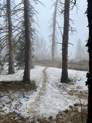
Pajarito summit
Before long I was heading down towards town on a narrow trail through Pajarito Canyon. It felt good to finally run again, but I had a hard time restraining my speed because of the steepness of the path. Plenty of rocks were underfoot to keep me alert and there were many sharp turns and switchbacks to negotiate. I stumbled several times on the way down, but managed to stay upright. The weather seemed to be clearing up and I considered taking off my jacket, but then the sky would turn dark again. I caught a couple of runners that had passed me earlier on the climb. I seem to be faster on the downhills; that’s where I usually pass other runners.


50K Course Flyover:
 

It was a long trek down, but I made it to the Camp May Rd aid station at around mile 21.5 to fill up my water bottles. As soon as I left, I heard loud cracks of thunder overhead; large drops of rain began to fall and the temperature dropped quickly. Nothing to do, but keep running, so I pulled on my hood. Soon I came to one of my least favorites parts of this course. Just before entering Los Alamos National Lab land (NO PHOTOGRAPHY!), there is a short but very steep slippery sandstone descent. I usually pull out my poles for this section, but was feeling too lazy. Instead, I opted to butt scooting down parts of this treacherous trail. 

Yep!
I crossed a road and then all hell broke loose, or should I say hail! “The sky is falling, the sky is falling!” The heavens opened up, dumping pea sized ice that bounced loudly off my rain hood. Did you know hail hurts!  On each flash of lighting I covered my ears with my gloves before the claps of thunder came. This storm was right on top of us!

I ran a narrow deep path full of water and ice which soaked my shoes. I crossed another road and ran under power lines while flashes of lightning were quickly followed by thunderous booms. I ran down an eroded hill, that was more like a muddy stream, anticipating the moment when the power lines might come crashing down on top of me. I was not in a good place, but just kept running.


Pretty soon I reached another dreaded cliff-like descent to the city ice rink where the next aid station was located. Narrow steep switchbacks are risky enough, but now they were covered in an inch or more of ice. If you slip off the trail here, you’re going down in a very bad way. I approached cautiously letting another runner go in front of me. I thought to myself, let him test out the waters first; see if he goes ass-over-teakettle! He seemed to have made it OK and he didn’t have poles but nevertheless, I took my sweet time going down.


I made it to the Ice Rink aid (mi 25) where some volunteers were sheltering in the back of a box trailer. I tried to pull one of my collapsible water bottles out of my vest pocket, but my fingers were numb and practically useless. A kind volunteer offered to grab it for me and filled it up so I could be on my way. I thought about dropping out of the race at this point, but realized that I would have to stand around in cold wet clothes waiting for a ride, which is a recipe for hypothermia. 

I took these in town the day after.


Anyway, with no time to lose, I took off and reached a hail covered highway that passes through a narrow canyon. An SUV drove past creating deep ruts in the slush. I plodded through to the other side and climbed a series of switchbacks leading up another steep cliff-like face. Surprisingly, the trail wasn’t too slippery because the ice was very wet and slushy, but the steepness took it out of me. I was really ready for this race to be over, but I still had another seven miles to cover.


The rain and hail stopped, but I became chilled whenever the sky darkened and the wind picked up. I had a dry expedition weight thermal shirt in my pack just in case, but I didn’t want to stop to put it on. I figured as long as I kept running, the effort would keep me warm enough. The route was hard to follow now, because it traverses snow covered slabs of rock; I mostly followed runners’ footprints while watching for course markings. Several times my foot sunk down into ankle deep puddles re-soaking my socks and shoes. It didn’t matter at this point, I was drenched to the bone.


My progress was slow, but I eventually made to the last aid station that looked like a tornado had struck. The shelters were blown down and a volunteer was on the phone tracking the location of runners who may have dropped out of the race. He asked if I was going to continue on and I said, “yes, all I want to do now is blast home!” He filled up my water bottles and sent me on my way. The last four miles weren't too bad; there was quite a bit of downhill and flats to run, but the mud and slush made the footing dicey in spots. I was really beat after a rough day in the mountains and longed for a hot shower and dry clothes. 

Mitchell Aid before and after (photo: JMTR)


Race text alert system
Eventually, I rolled into the finish line looking like a drowned sewer rat in just under 11 hours; 30 minutes slower than last year, but happy all the same. It was one heck of a tough day, but they can’t all be blissful. “No mud, no lotus.” You cannot have one without the other; you have to take the bad with the good. It all evens out in the end. Sadly, I didn’t take many pictures because my hands were numb. As I write these words a week later, the feeling has returned to my left hand, but the tips of my fingers on my right are still a a bit numb.

Jemez finishers' award

The race officials did a great job tracking runners and ensuring everyone’s safety. Some 50 mile runners were diverted from their longer course because of the storm and many runners dropped out to prevent hypothermia. Others were driven by volunteers to a nearby house to shelter, recover and warm up. 


“What an adventure, but amazing support from kind people, volunteers, friends in the wilderness medicine community and complete strangers, who opened their homes to a dozen shivering runners.” —Adam Delu


Read more here: Runner Describes How Severe Weather Affected 2024 Jemez Mountain Trail Run Events Saturday

Indian paintbrush
It was another wild running adventure that I’ll never forget. Thanks to all the volunteers and race staff who sacrificed their comfort; enduring the cold and icy weather to support the runners.


See you on the trail. 


Sunday, October 8, 2023

Mt Taylor 50K

 Recently I ran the Mt Taylor 50K in Grants, NM, which was my fourth finish on this sacred mountain that tops out at 11,300'. If you know me, then you understand that mountains, forests, deserts and rivers are my church. You could also call it your synagogue, mosque, temple or simply your happy place; It doesn't matter. Mt Taylor, known as TsoodziÅ‚ (Turquoise Mountain) to the Navajo is one of four sacred mountains that mark the boundary of their nation. 


According to author, Tony Hillerman's version of Navajo mythology:

First Man buried turquoise in this range, hence its symbolic blue color... the chief of the Enemy Gods, Yé'iitsoh, once resided in this peak. When the Twin War Gods (Born for Water and Monster Slayer, sons of Changing Woman) killed Yé'iitsoh, his blood spilled down the slopes and hardened into the lava flows of El Malpais in the area surrounding Grants. The mountain features as a central and meaningful location for Blessingway and Enemyway ceremonies.

Saturday, May 27, 2023

Jemez Mountain Trail 50K

I ran the Jemez Mountain Trail 50K in Los Alamos, NM this past weekend, which is one of my favorite races. I keep coming back year after year to enjoy the beauty of the land and to test my mettle under the always challenging conditions. The terrain is tough, with short steep climbs in and out of deep canyons as well as a long slow grind topping out at 10,400’ elevation on the Pajarito summit. This event offers 50 mile, 50K and 15 mile courses, with staggered start times, so you can pick the level of misery you would like to experience. This year I chose the intermediate suck level.

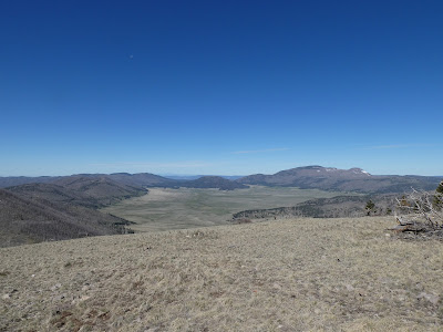
Valle Caldera National Preserve on a cler day

This was my 9th attempt. In years past, I’ve completed five 50 milers, one 50K and have had two DNFs, one for runners being halted mid-race for a freak snow storm! I was running down the mountain in heavy cold rain while it was snowing on the peak. When I arrived at the the next aid station at the bottom, they informed us that the race was called off because some runners at the top were suffering from hypothermia and other cold related injuries.

Los Alamos and the Jemez Mountains


Sunday, October 3, 2021

Mt Taylor 50K 2021

 The muffled sound of a hundred feet padding the rocky dirt road, a whiff of dust stirred up from the forest floor and the disorienting ovals of light from runners’ headlamps greet me at the beginning of the Mt Taylor 50K in Grants, NM. I carefully scan the road for rocks lest I break my ankle in the first half mile of the race. Mt Taylor (11,306’) or TsoodziÅ‚ is a sacred mountain to the Navajo and marks the southern boundary of their homeland. According to the website NavajoPeople,

“[TsoodziÅ‚ ] is important in the Blessing Side ceremonies and the Enemy Side Ceremony. Mount Taylor was once the home of Yé’iitsoh (Chief of the Enemy Gods).
Once the sun is up, sunrays are all around and Mount Taylor is adorned with sunlight.

After thinking about what you want to do for the day, you start to plan your activities…Thoughts such as, “We want to progress,” grow from small plans to large plans and Mount Taylor has the power to satisfy that wish.”

View from Mt Taylor elev. 11,302

My hope is that Mt Taylor will be kind to me today and allow me to progress up her steep slopes and to safely return to the race finish line. I’m barely awake and simply keep my mind focused on the path. I share the trail with about 150 other hearty runners, but I stay in the back of the pack and pace my self. Before long the road becomes steep and I shift into power hike mode to conserve as much energy as possible. I expect my journey to last about 9 hours.

Saturday, March 28, 2020

Charmin Covid -19 Marathon Race Report

Earth is closed until further notice! The Coronavirus pandemic is in full swing. Like every other human on our planet, I have been social distancing, quarantining, sheltering in place or whatever else you want to call it. For me this isn’t much different than how I operate anyway, so I suppose I’m lucky in that regard. We have been spending time at our family’s ranch in West Texas which is what we normally do over Spring Break. Hudspeth County, TX is one of the least populated counties in the US so I have to laugh when authorities say to keep a six foot distance from others. Out here it’s closer to six miles!

The Ice Cream Cone, Indian Hot Springs Rd
Anyway, I was supposed to run the Bataan Memorial Death March for my 9th year in a row, but of course it was cancelled. Instead, I signed up for the Charmin Covid-19 Marathon that was run out here in the Chihuahuan Desert. About five of us hearty runners started out at first light for our 26.2 mile adventure.The weather was nice and cool in the morning when we began our run along a dirt road that runs near the border of Mexico. 

Monday, March 25, 2019

Bataan Memorial Death March

KABOOM! Uh-Oh! I think I pooped my pants a little bit. Nothing like having soiled running shorts before you’ve even completed the first mile of your marathon. Just kidding, but those starting canons at the Bataan Memorial Death March at White Sands Missile Range, NM were loud. Really loud!. Surprise!

Heading through the misters
Every year I show up before dark, along with thousands of other marchers, to honor the survivors and remember the fallen of the Bataan Death March in the Philippines during WWII. There are always some survivors in attendance as well as members of congress and other dignitaries. This was my eighth year braving the cold, wind, heat, sand and hills of the 26.2 mile course. No matter how much we suffer though, we can never fathom the horrors that these WWII heroes endured. This event, the largest joint military/civilian athletic competition, ensures that the survivors know how much we appreciate their sacrifices. At the time of their march and detainment, POWs thought they were completely abandoned as the following poem attests, 

We're the Battling Bastards of Bataan,
No Mama, No Papa, No Uncle Sam,
No aunts, no uncles, no cousins, no nieces,
No pills, no planes, no artillery pieces,
And nobody gives a damn!


—Frank Hewlett


Monday, January 14, 2019

Deep in the Heart of Texas

Bandera Texas is the Cowboy Capital of the World (yes, the world!) and the future home of Amy’s Sweet Ass Honey Co. More on that later, but for now I’d like to tell you what happened at the Bandera 100K this year. Heavy rain caused the rangers at the Hill Country S.N.A. to cancel the race. Tejas Trails moved the event several hours away to Camp Eagle, but by this time I was already in Central Texas with Cara and Maddie visiting family. Also, we had plans to stay with our friends who live in Bandera, TX so we kept to our original plans and had a good time vacationing in Austin, San Antonio and Bandera. 

Texas Hill Country outside of San Antonio
Our friend Amy and her husband Michael live several miles from the state park in Bandera and frequently ride their horses on the trails there. Amy told me that the park has a new superintendent who is very particular about the trails and that park staff and volunteers spent many hours restoring eroded and rutted trails after recent floods. In addition, they had a serious gully washer the week of the race so the Bandera Trail Run was a no go.

Maddie, Cara and Amy (L to R)
Eisenhower Park, San Antonio, TX
The day after the heavy rain we stopped in San Antonio ("San Antone" if you are Texan) and I was able to run the trails in Eisenhower Park. I’ll tell you about the trails in just a bit, but wanted to first let you know that this is home of the Alamo City Ultra that Trail Racing Over Texas put on last year. There are about six miles of different trails and the Alamo City Ultra used a 5K loop that was repeated 10 times for their 50K. The park is just on the outskirts of San Antonio where the Texas Hill Country starts. The area is mostly made of karst formations which are defined as “landscape underlain by limestone that has been eroded by dissolution producing ridges, towers, fissures, sinkholes and other characteristic landforms.” In other words, it’s some gnarly ass terrain to run on.

Gnarly stairs
Big roots
San Antonio is very protective of their water quality because all the surface runoff from rain pours through the porous karst formations into the Edwards Aquifer which supplies the city’s drinking water. Eisenhower park is in the recharge zone so they request that you pick up all your dog’s poo lest it run into the aquifer. Gulp! In addition, cities like San Antonio and Austin purchase tracts of land, that are off limits to people, to protect their precious water source.


I picked a great day to run in the park; the weather was warm and sunny. I started out on the Hill View Trail going counter clockwise. It was pretty smooth with a slight incline at first and then gave way to some bumpy limestone outcrops. Pretty soon I hit a steep section of stairs that were shored up with some cedar timbers to control erosion. Roots and loose rocks fill the steps making for some treacherous footing. I continued to climb and then reached a section of smooth protruding limestone; some very porous in spots. I was mostly under a cover of juniper (mountain cedar) which dominates the Hill Country. Prickly pear cacti and sotol, a succulent with thin, waxy, serrated leaves, line the trails.

Sotol

Once at the top of the escarpment, I passed by a fence; the perimeter of Camp Bullis, a training base for the Army. Throughout my run I could hear machine gun fire in the distance. Soon I started down another trail with high steps of wet smooth rock which made them quite slick. My foot slipped out from under me a few times, but I finally made it back down. Then I turned onto a paved path for a short distance and ran to a wooden tower that affords great views of the Alamo City skyline and the Texas Hill Country with upscale houses interspersed along the rolling hills.


San Antone skyline
After taking in the sights, I took off and continued along the main trail. When I arrived back at the parking lot I decided to go around again, but explored a few of the inner trails crossing a few picturesque bridges and a field with several bat houses. I was impressed with the trails in the park and knocked out almost 7 miles. While Eisenhower isn’t a large park, there are a variety of trails from easy paved paths to steep treacherous technical trails. 


Field with bat houses
The following day, I woke up early and ran to Helotes, TX which is also on the outskirts of San Antonio. I lived near here for five years where I trained for some marathons and a few ultras. I rarely run paved roads anymore, but wanted to run one of my old haunts, the Scenic Loop through Grey Forest. The best place to start is at the John T. Floore Country Store, a historical landmark, where a sign boasts “Willie Nelson Every Sat. Nite”. In fact, Willie performed here frequently in the early days of his career and still returns occasionally. I actually had the opportunity to hear him play at Floore’s when I lived here. 

Floore's
Helotes Creek
Anyway, I ran through the little town of Helotes and then crossed Bandera Hwy 16 where I picked up the Scenic Loop. This is a very popular road for cyclists and there is just enough gravel shoulder to safely run along the side of the road, but be careful. You will cross Helotes creek several times and also run along the meandering stream where there are nice views. I passed many beautiful stone homes under ancient towering oaks and one historical mansion, the Marnoch Homestead. 

Helotes Creek frequently floods and erodes the limestone
Marnoch Homestead
Eventually I reached the city of Grey Forest (“A Scenic Playground”) home of the Grey Moss Inn, a restaurant that was established in1929. The picturesque homes in this area are reminiscent of a miniature Christmas cottage village sitting under Spanish moss draped trees. The best part of the scenic road though, is a train passenger car and caboose that have been recently restored. I’ve always been a train buff since my model railroading days as a young lad so I stopped to admire them before I turned around to head back to Helotes. 

Scenic Loop


Following my run, the fam and I drove to our friends’ house in Bandera Texas where we visited and got to know their horses, dogs and cats. They live on a 15 acre spread where trails lead from their house to the equestrian trails in the state park that we usually run on during the Bandera Trail Run. Bandera proper is a small Texas town with western wear shops, a general store, restaurants and plenty of cowboys roaming about. We had breakfast in the O.S.T. (Old Spanish Trail) restaurant that features a John Wayne room and where you can literally saddle up to the bar; the barstools are actually horse saddles. 

O.S.T. Restaurant

While visiting Amy’s ranch, I took a particular liking to her donkey, Queso who, in true Texas style, came included in the purchase of her house and land several years ago. (Leave it to me to befriend an ass.) Amy eventually plans to raise bees and start a local all natural honey company so she can lead Queso drawing a wooden cart through the streets of Bandera to peddle her honey. So the next time you run the Bandera Trail Run or happen to be in the Cowboy Capital of the World keep an eye out for Queso and Amy’s Sweet Ass Honey.

My buddy, Queso
See you on the trail.