 |
| The ghost town of Banderas, Mexico |
Downstream from Fort Quitman (20 miles south of Sierra Blanca), and before it reaches the village of Porvenir… the river enters into what has become known as the Forgotten Reach. At this point, choked with constantly advancing tamarisk trees [salt cedar], it loses force and direction as it multiplies into numerous small streams. It emerges, almost sucked dry, upstream from Candelaria, as a gentle, small stream, ankle-deep as it widens or jumpable at the narrow sections. —Jim Glendinning, Big Bend Now
 |
| America in the foreground. Mexico in the background. |
I started out by running FM 192 in Hudspeth County, a desolate strip of rolling pavement that parallels the Rio Grande. There are numerous low water crossings that pass through dry sandy arroyos that can quickly turn into raging streams during a West Texas gully washer. Soon I arrived at a portion of the road that was completely under water a year ago. The highway department has since brought in truckloads of gravel to raise the road.
 |
| Running FM 192 with my cohort, Harry (Potter) |
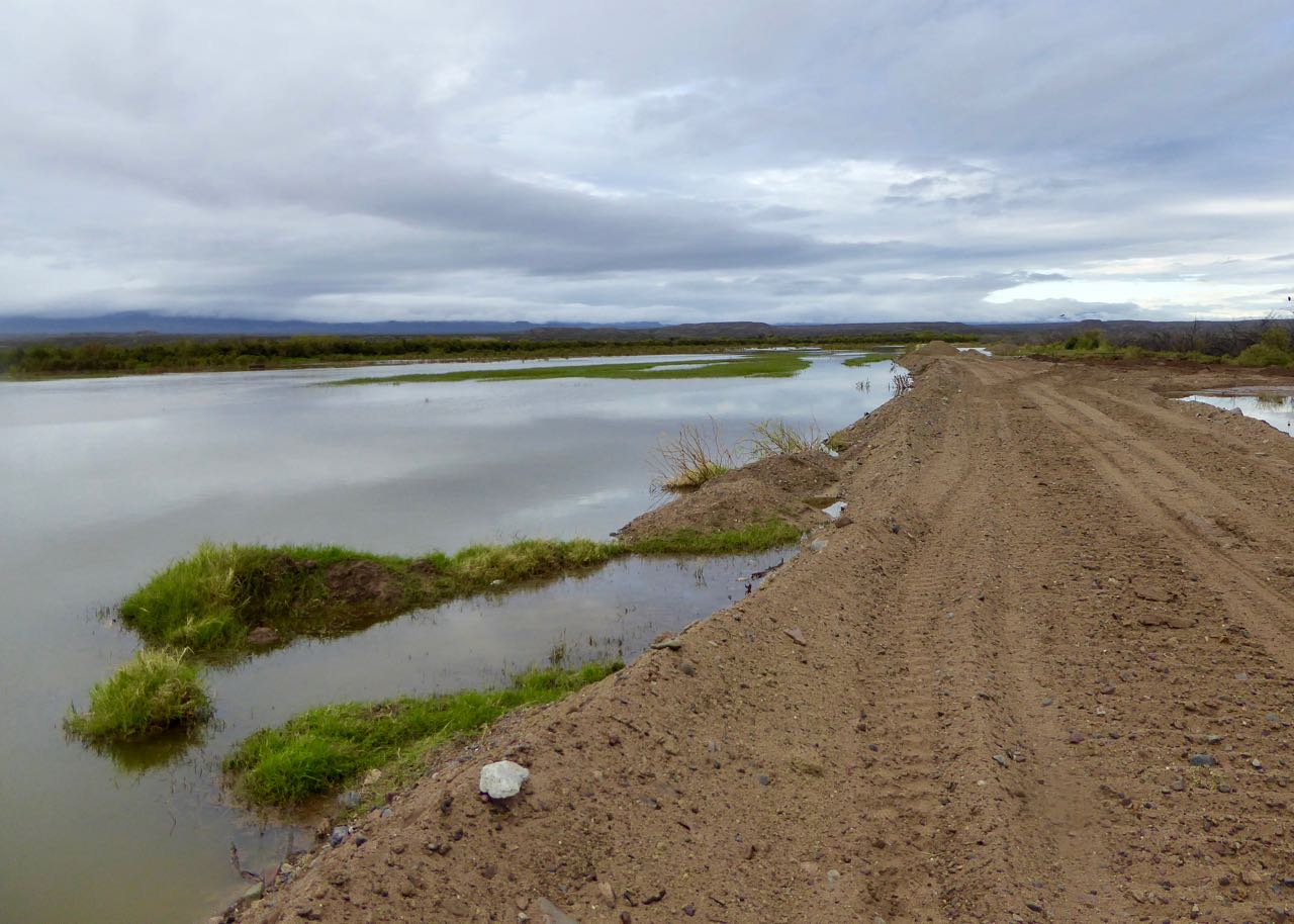 |
| Rio Grande levee |
Adjacent to the highway is the beginning of a four mile stretch of border fence. Don’t confuse this with Trump’s border wall which is to be: “30 feet high, made of solid concrete, sunk six feet underground, unclimbable and aesthetically pleasing on the north side.” This particular fence was erected after G.W. Bush passed the Secure Fence Act of 2006 and is more specifically, a vehicle barrier; not a pedestrian fence. Only a small number of hearty ranchers are brave enough to live in this unforgiving landscape in the Chihuahuan Desert anyway.


The area near the fence was completely flooded and teaming with beautiful birds. White egrets took flight as I approached and half a dozen turkey vultures, with their telltale red heads, were perched in the trees waiting to pick clean the corpse of anyone who was unfortunate enough to attempt to cross the rugged mountains and inhospitable desert.


After snapping a few pictures I continued on running along the border levee road and fence that was flooded on both sides. The gravel crunched underfoot as I ran a good pace on the flat road. I tried peering through the gaps of the iron fence posts to see the birds on the other side, but it was like watching an early 20th century flicker show and I started to get nauseous after a few minutes.

After running for some time I heard a startling noise on the Mexican side of the fence —a bunch of splashing and flailing in the water. I caught up to the melee and discovered that there was a herd of wild horses stuck between the flooded Rio Grande and the border fence. They spooked as I approached them and ran along the barrier occasionally dashing into the water. There must have been a dozen or more with a few foals sticking close by their mothers. Fortunately there was plenty of grass and water to drink so I believe they will eventually find their way out, but at the time, they seemed alarmed at their plight.
Watch Video:
 |
| Wild Mexican horses |
I continued my running adventure and flushed a cover of American coots (yes, cover is what they’re called). They were on the American side, of course; otherwise they would be Mexican coots. (That was a joke). When these black duck like birds with white bills saw me, they skittered along the surface of the water, their webbed feet paddling at the water while their wings flapped wildly.
 |
| Cover of Coots |
Then I came to a quaint white house with red shutters, a remnant from ranching days gone by. Unfortunately it was completely surrounded by water. Mt Quitman loomed in the distance and was shrouded in a blanket of fog, clouds pouring down the slopes like molten marshmallow from a Willy Wonka volcano. At the base of the mountain sits a rock house that was once a two room school house for children of ranchers and ranch hands. It has since been converted to a two bedroom home. I had never seen it from this perspective; with a lake in the foreground; coots floating peacefully along the glasslike surface.
 |
| Mt Quitman |

The rain came and went as I ran, but the air was really sultry and I was soaking wet. The clouds helped keep me somewhat cool though. A little while longer, I came to another ranch house that looked very well kept; an American flag flapped in the breeze. The roof looked new and there was a lush green lawn that led to the waterfront. This one was occupied and hadn’t succumbed to the flooding. Not yet, at least.
 |
| Rock house |
 |
| This one hasn't been flooded yet. |
Soon it was time for me to turn around and head back, but I stopped for one more look through the cracks in the border fence. Mexico looked no different than America. It was a flooded marshland teaming with water birds. I could see snowy egrets and one great blue heron that appeared ginormous as seen through the slits in the fence. Beautiful mountains towered above the valley and I couldn’t detect the faintest sign of civilization. There is nothing out here, but the most rugged and harsh landscape imaginable. A handful of ranchers on both sides of the border have made their living here over the years, but those days are mostly gone now. Before leaving I watched a spider who had made his web between the ironmongery of the barricade.

 |
| Snowy egret as seen through the border fence. |
As I ran back, with nothing better to do, I pondered the reason this land has flooded after years of being mostly dry. I came up with no answers, but formulated several hypotheses. One is that the International Water and Boundary Commission has forgotten to dredge the river channel which is causing the river to back up. The other is that the engineers of the fence have forgotten that surface runoff is supposed to flow into the Rio Grande, but the concrete barriers are now impeding that flow. I also couldn’t help wondering what the future holds for these ranchers if the fence is replaced with a solid wall (that is to be aesthetically pleasing on the north side).
 |
| Snowy egrets |
A concrete structure which impedes the flow of water in or out of the river is not permitted in a floodplain per US/Mexico Boundary Treaty of 1970. According to NPR, “The treaty states both U.S. and Mexican officials on the International Boundary and Water Commission must agree if one side wants to build any structure that would affect the flow of the Rio Grande or its floodwaters.” In addition, river hydraulics experts say, “…concerns over floods on the border are well-founded. [They] point out that a wall built in a floodplain acts like a dam. During torrential rains, these obstructions deflect water and worsen flooding.”

If a wall is built outside the floodplain, some Texas land owners could end up on the “wrong” side of the wall as happened to several families in Brownsville, TX. Furthermore, the fence is built a mile from the border in some areas which led to the closing of the Ft Brown Golf Course when it was left on the south side of the border fence. According to CNN, “Federal officials say it was unfortunate some families wound up on the wrong side of the fence. They estimated it happened about a dozen times…”
And this brings me to my last question — Will the rest of America care about a handful of ranchers in one of the least populated counties in the US or will these Texans be forgotten along with the Forgotten Reach of the Rio Grande?
See you on the trail.
Texas Observer: The Texas-Mexico Border Wall Comes With A Dangerous Side Effect: Flooding
NPR: Mexico Worries That A New Border Wall Will Worsen Flooding
USA Today: This Texas golf course had no chance stuck behind a border wall
CNN: US Family Stranded on South Side of Border Fence
CNN: US Family Stranded on South Side of Border Fence