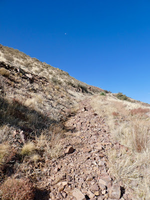
While carefully descending a precipitous slope with loose golf ball-sized rocks, my foot suddenly slips from under me. I catch myself with my hand into a prickly pear cactus while also sitting on another cactus! When I regain my bearings and pull my hand out it looks like a pin cushion. There are large thorns protruding from, not only my hand, but also from my calf and shin because my foot slid into another cactus. 10 big thorns are in my palm and several clusters of those little annoying hair like ones in my fingers. Schaeffer Shuffle trail in the Franklin Mountains State Park, El Paso, TX is my least favorite trail especially the steep descents.
 |
| Franklin Mountains State Park |
I started in the dark on the Upper Sunset Trail which begins with a steep ascent on rugged terrain dominated by shin dagger and other pointy vegetation. The footing is rough with rock formations protruding from the ridge like the spikes and frills of a dragon’s back, making it nearly impossible to run. The morning air was somewhat sultry and the effort drenched my shirt with sweat in no time.
In about a mile, I descended to the main park pavilion and then ran down the hill affectionately known as Big Bertha picking up Schaeffer Shuffle. I passed through an arroyo and ran along a rocky gorge below the main Franklin mountian range. The ascents here are also steep and gnarly with shards of perpendicular slabs of rock protruding from the earth. Now, if I could just get down this slope without another mishap.
 |
| Sotol succulents |
I pluck the largest thorns out of my hand but several are completely imbedded having been broken off when I fell. I slowly and carefully make my way down the mountain and run the Lower Sunset Trail back up to the main park pavilion. I stop here to eat some boiled potatoes and apple slices while digging my first aid kit out of my pack. I pull out the most important item in my kit, a small pair of tweezers. I pluck the small thorns out of my hand and a few that are stuck in my ass. I’m able to dig out several of the large imbedded ones, but one is too deep so I give up and continue on my way.
 |
| Aztec Caves |
I cross the park road and begin my journey up to the Aztec caves which have nothing to do with Aztecs. In the early 1900s local El Pasoans found artifacts in these caves and misattributed them to the Aztecs who actually lived in central and southern Mexico. The sun is finally peaking over the range flooding the tips of the peaks in golden light. This trail gets steeper as you approach the caves especially after crossing a foot bridge spanning the arroyo. The caves are set in what looks like a big glob of molten lava that randomly fell from the sky; reddish in hue. After much toil I make it to the largest cave and step in to take the obligatory “cave-view-looking-out” photo.
 |
| Cave-view-looking-out |
 |
| The scramble above the caves |
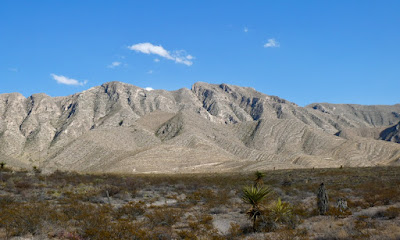
I clamber up a smooth steep slab of rock using my hands and reach a sketchy trail that takes me just beneath the backbone of the Franklins. The outcrops are an other planetary shade of red adorned with sotol, a succulent with narrow serrated leaves and ocotillo cactus which look like electrified hair standing on end. The view is outstanding, the sun bathing the alluvial fan stretching into and Rio Grande Valley below. The path is narrow in places and close to precipitous chutes where a slip would send you sliding off a cliff. I’m very careful and trying my best to not look down. In about a mile I reach the Mundy’s Gap Trail and run down the mountain.
I slip several times on loose gravel and make it to a steep section that leads to a narrow part of the trail where a cliff rises on the right and a boulder and wood filled gully on my left. A flood washed away much of the trail here years ago leaving a sliver of pathway in its wake. I reach a huge scree field with irregular shaped, bowling ball-sized, ankle twisting rocks and attempt to run on them without much success. They shift and clack underfoot causing me to trip several times, but after an “F-bomb” and a couple of “Jesus Christs!” I’m safely down to the aid station in the parking lot. You may say, “There’s no aid station, the race was canceled!” But I say, NO IT WASN’T!” I can clearly hear the people cheering me in, cowbells ringing vigorously. My friends and other selfless volunteers are here giving out free hugs.
I touch the pavement with my toe and turn around to start my arduous journey up to N. Franklin Peak (7192’) turning onto the Agave Loop Trail. All the usual TROT racers are here too. The guy on the side of the trail pulling thorns out of his shoe where he inadvertently kicked a cactus, the girl puking in the bushes and that dude with Led Zeppelin emanating from his earbuds who is about to step on a rattlesnake.
Anyway I slowly plod upwards crossing several small scree fields and then run down to a large tongue of scree pouring down the side of the mountain. I traverse this obstacle and then climb the steep stairs up to the giant cottonwood tree at West Cottonwood Spring. My heart is pounding out my chest so I stop to rest at the muddy seep below the tree. I begin the scramble up to the main Franklin ridge on a faint path and have to stop often to catch my breath. I like to use trekking poles on this section, as well as on Schaeffer Shuffle, but I didn’t want to carry them all day. Now I regret my decision.
 |
| Scree leading to West Cottonwood Spring |
I reach the top and can hear the cowbell coming from the Mundy’s Gap aid station where my friends are waiting to fill my water bottles. (Yes, they are!) I cross over to the east side of the mountain and can see El Paso sprawling across the desert floor below. A box of parallel and straight as an arrow roads, carefully engineered strip malls, neighborhoods and other infrastructure contrasting the chaotic irregular shaped landscape and treacherous terrain up here at 6000’ where everything bites, stings and scrapes.
 |
| NE El Paso in the distance |
I clamber down off the ridge, hit a dirt road and then turn to start my four mile out-and-back to the N. Franklin Peak, the highest point in El Paso. The sun is full on now and I start to heat up as I climb upwards. It’s slow going and I can feel the burn in my legs while the altitude makes me light headed. I nibble some almond-stuffed-bacon-wrapped dates which beat sugary gels hands down. This gives me the energy I need to power hike up the mountain.
I get out of the way of the lead runners bombing back down, some with bloody knees and elbows from where they zigged instead of zagged, tumbling ass over teakettle down the mountain. I can’t see them, but I know they’re here, even the Tarahumara wearing nothing but a loin cloth and huarache sandals. This is a badass race indeed!
 |
| Trail leading to N. Franklin Peak |
I reach a saddle and climb through a rocky gully and then switch back my way towards the peak. The closer I get to the top the gnarlier the footing with rocks strewn willy-nilly all over the trail. A Dark-eyed junco flits about right under my feet, hopping about as tame as can be. I feel like I could reach out and grab him, but he takes flight almost colliding with me. I make the final push to the top, pausing several times to rest my legs.
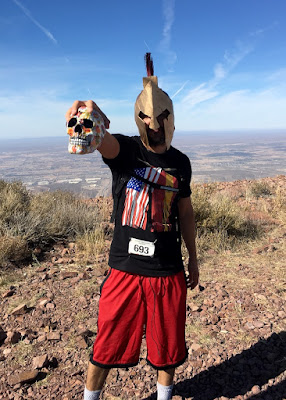
When I reach the top, all the racers are high fiving each other and taking selfies. Even a dude wearing a creepy medieval helmet holding a calavera, the iconic decorated skull of the Día de los Muertos (Day of the Dead) celebration. Those loved ones who’ve gone before us are never dead until we’ve forgotten them. You may say they are gone, but I say they are not. You can clearly see them if you look deeply.
 |
| Told you there was a creeping medieval dude |
Anyway, I take in the 360 degree view where I can see the mountains of Mexico, New Mexico and Texas. Indian peak, with its tiny rusty hut, is the bump to the east in the Castner Range (formerly Ft Bliss). There is a local effort to clear this donated Army land of unexploded ordinance to create a national monument. If you'd like, you can reach the hut from the saddle by going past the sign that reads, “UNEXPLODED AMMUNITION DO NOT ENTER” and scrambling up to the peak.
 |
| Indian Peak |
 |
| That time I went to the hut |
Anyway, I don’t waste any time because I have a long day ahead of me on my circumambulation of the Franklin mountain chain. Going down the hazardous route is almost as slow as coming up and I trip and stumble frequently on the many obstacles in the trail. I’m able to keep myself upright for the most part though and eventually make it back to Mundy’s Gap where I stop to refill my water bottles. I proceed down the east side of the range continuing on a counter clockwise loop.
People often ask me, “What do you do for hydration when you run that long in the desert?” “I save my own urine”, I tell them. Just kidding, that would be gross! I really have several caches of bottled water out here. I hike in a few miles from Anthony’s Gap in the north and from the Tom May’s Unit of the state park to stash my water in small rock “refrigerators” that I constructed. I also have my trusty assistant, aka my personal trainer, aka my life coach, aka my therapy dog, Taz to help stock my fridges.
 |
| Taz, my trusty assistant |
I run down a steep road past cliffs and rock protrusions and reach the base of the mountain where there are some abandoned tin mines. The official Franklin 50K course goes up and around these mines through a bunch of overgrown brush and arroyos, but there are several families with kids crawling around checking out the mines. Everyone looks a little virus-y to me so this gives me a great excuse to forgo this most unpleasant part of the course. I continue straight on Scenic Rd Trail, one of my favorites, because the footing is so smooth.
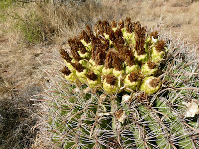
I stop briefly to put on some sunscreen and eat some more snacks. Heat is my worst enemy right now, so I also make sure to hydrate often. I wind around the contour of the mountain with a few short uphill sections. I pass through a sotol forest with occasional barrel cacti with yellow fruits on top that resemble mini pineapples. They don’t taste like pineapples though and those little thorns are really hard to get out of your tongue!
 |
| Barrel cactus, do not eat! |
I run through an area dodging smooth goblin like sandy rocks, serrated edges of sotol scraping against my thighs. I reach yellow-green rock and know I’m nearing the Newman Trail. I pass through a wide gravelly wash and pick up the trail. I slog upwards for quite a while finally reaching another pass. The trail down is a long and windy gradual descent. The lower I go, the hotter it gets though and my energy is waning.
 |
| Yellow-green rock |
I slog on and reach the Hitt Canyon Trail and slowly grind along the mountain. This is the most remote part of the park and I rarely see anyone out here. If you have a mishap here and become stranded the vultures, coyotes and cougars will devour your flesh before anyone even notices you are missing. Let’s hope today doesn’t turn into a running adventure gone horribly wrong!
 |
| Northern end of the park looking into NM |
Soon I reach the Hitt Canyon and run along the rim trying to keep a steady pace. The Northern Pass over to the west side of the mountain comes into view, but I have a long twisty ribbon of trail to run before ascending to the pass. Mountain walls rise up all around me with wide open desert in the distance.
I pass several racers here because this is the place where runners who go out too fast come to die. On a hot day they may be out of water. This is the dumping ground around mile 25 of the race where their legs are limp, knees destroyed, feet blistered and dreams dashed. They limp into the last aid station waving a white flag and curl up in the fetal position. You may say the race was cancelled this year, but I say it was not! I can clearly see the misery on their faces.
 |
Fortunately for me, I didn’t go out too fast and still have enough water to make it to my next cache. My legs are rubbery and I’m tired, but think I’ll be able to make it out before the coyotes and vultures get to me. Eventually I reach the Northern Pass where the desert spreads out for as far as the eye can see. I run down a series of perilous rocky switchbacks, one with a high step down that I have to negotiate carefully lest I fall on another cactus.
 |
| Northern Pass |
Once down, the terrain is pretty smooth though. Heat from the sun radiates off the earth and a dry wind blows down the slopes creating a natural oven and now I’m out of water. I run down an old ranch road and reach my water cache. I fill up two 20oz bottles and two 8oz ones and then, pick up the Lower Foothills Trail. My mouth becomes dry from sucking the hot dry air.
 |
| Anthony's Nose |
This is the most dreaded part of the entire 50K course, not because it’s steep or technical, but because it’s between miles 27 and 33 and it’s usually hot by the time you get here. It's called Tommy’s Revenge named for my friend Tommy who hates this stretch more than anyone. In fact, I can clearly hear him behind me bitching about how damn hot it is and asking if we will ever get there. The first part of the trail is interesting, dipping in and out of arroyos, but then I reach a long boring stretch that is on a gradual uphill.
This segment is somewhat featureless and you are far away from the main mountain chain rolling along open dusty desert with Anthony’s Nose in the distance. Eventually Mammoth Rock comes into view though, and my mood picks up because I know I’m nearing the end. Even though my body is wracked with pain, my feet are tender, and I’m hot and exhausted, the peace and quiet out here is unsurpassed.
 |
| Mammoth Rock |
 |
| The last ascent to the finish |
I run along some rocky outcrops, in and out of a few arroyos and finally reach the dirt road that I ran this morning at mile three. I slowly start the climb back to the main pavilion where I can hear all the people cheering for the runners and ringing the cowbells loudly. (Oh yes I can!) How glorious to climb the final hill on an uneven slab of rock. My legs burn as I conquer the stairway to heaven, aka cement steps to the pavilion. All my friends are here and the cots are full of dead and injured runners some having their bloody knees stitched up; others looking pale and ghostly.
 |
| N. Franklin Peak |
 |
| New visitor's center |
My gps watch reads 33.6 miles in 10:40 and so I sit down at an empty picnic table to recover and cool off. I’m truly beat, but the journey was life changing as always. It never gets old no matter how many times I take on this challenging endeavor. Suddenly, I realize that my car is two miles down the park road and I have no way of getting there except by my own two feet. What’s two more miles after already running 33.5?
See you on the trail.
 |
| Elevation profile Franklin Mt 50K |
Franklin Mt 50K course on Strava:


