I love the sting of shin dagger in the morning, don’t you? There’s nothing like starting a 50K trail run on a cold dark morning, pointy vegetation lapping at your ankles and shins while you slog up a rock strewn trail that ascends 400 feet in about a half mile. The Franklin Mountain Trail 50K, held in the Franklin Mountains State Park in El Paso, is the toughest of its kind in Texas. Later this morning we will climb up to the N. Franklin Peak at 7192’ elevation and the entire course has around 7500’ of total vert, qualifying it for the USA Skyrunner series. I’ve never run this race, but have been training on this course for quite a few years so I know every twist and turn, rock garden and Spanish bayonet plant to watch out for. Even so, one can never fully prepare for the Franklin Mountains; they will destroy your body and soul!

 |
| N. Franklin Peak Photo: Trail Racing Over Texas |
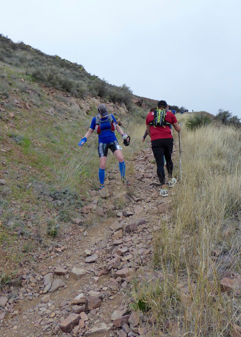
My strategy is to take it easy in the first half of the race where all the steepest and longest climbs are to make sure I have enough energy to run the second half which is somewhat flatter. I hope to finish in about 10 hours. The sun isn’t up yet as I climb the first hill along the Upper Sunset Trail. I follow the train of 180 headlamps snaking their way up the mountain. Just when you think you are done climbing, you realize you aren't, and then have to continue up another steep rocky slope that resembles a cliff in spots. In about a mile, I run downhill, through the park pavilion and then pick up a wide road that is affectionately known as Big Bertha for the steepness of her grade. Luckily I’m headed down this morning.
 |
| N. Franklin Peak (7192' elevation) |
I pass as many people as possible and then turn right onto Schaeffer Shuffle trail crossing a dry wash and then I ascend another steep rocky trail. I rarely go on this trail because it is so gnarly and technical with the route traversing slivers of sharp crumbly rock. By the time I get to the top, it’s time to go right back down. This section is a treacherous eroded gully filled with softball-sized rocks that is not runnable at all. A backlog of runners bunches up here, patiently waiting their turn to tumble helter-skelter down the mountain taking as many of us with them. I slowly and carefully slip and slide my way down as several impatient runners go off trail to pass, scraping their shins on the lechuguilla (shin dagger) as they go by. I relish the opportunity to take my time early in the race, saving my energy for later.


Soon Schaeffer spits us out onto a wide dirt road which gives me the opportunity to run down, passing some more runners. I climb Lower Sunset trail and then reach the pavilion that I ran through earlier. This is also the mile 5 aid station and the finish line that I hope to return to later this afternoon if the Franklin Mountains don’t have their way with me. I fill my water bottles and run through a developed camping area and then begin the climb to Aztec Caves. You can see the caves from the park and think to yourself, how the hell am I supposed to get all the way up there?
 |
| Aztec Caves in the distance |
 |
| Climbing above the caves |
The trail is mostly up with a few short steep downhills through a dry arroyo that turns into a raging river during our monsoon gully washers. I cross a bridge and climb through a boulder strewn area and then hit the steepest part. I feel pretty good on this climb that left me exhausted and winded at times this past summer. I pass a few lowlanders who seem to be struggling on the steepest part. Finally I arrive at the caves and duck inside to snap a few pictures. Most of the runners climb past the caves, but I know the view is spectacular from inside so take a little rest break.
 |
| Jonathan C. |
 |
| Photo: Trail Racing Over Texas |
When I come out, I have to use my hands to scramble up a solid slab of rock. Blobs of cement have been strategically placed to help create footholds. I traverse the rock outcrop that has a sharp drop-off on one side. The rock is a smooth wavy pink, tan and gray with blotches of green lichen. The next mile or so is quite sketchy with just a narrow path and several exposed sections where a slip could really ruin your day. I take it easy and enjoy the view while passing several runners who are snapping pictures. The trail roller coasters along and some of the ascents require scrambling.
 |
| Runners scrambling up the upper "cave route" |
Pretty soon I’m back on a wide rocky road where I am able to make up some time by running downhill. There are several sections of fine loose gravel that make the footing very slippery. Nothing is easy in this race and then I reach a scree field. Loose bowling ball-sized rocks with jagged edges spill down the mountainside creating plenty of opportunities for a twisted ankle. The rocks shift and rock as I gingerly pick my way down the slope. I eventually make it to the 8 mile aid station and promptly begin climbing right back up the mountain again.
 |
| Talus crossing |
Soon I’m on a narrow trail with a precipitous drop-off down to the scree I ran earlier. After traversing several narrow talus slopes, the huge cottonwood tree by the spring comes into view and I climb down to a boulder and scree filled valley. The jagged rocks appear to be flowing down the mountain as if an evil ogre had vomited all its inner contents. Perhaps he consumed too many runners. As I’ve alluded to before, the Franklin Mountains will eat you alive!
 |
| Large scree field |
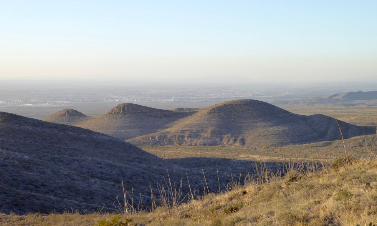
Anyway, I cross the rocks as they shift to and fro beneath me and then climb up to the cottonwood. Here the trail turns into a steep faint yak path up to the main spine of the Franklins. Runners sometimes get confused here and begin climbing right (South) up the ridge towards N. Franklin Peak. The route actually descends down to Mundy’s Gap first and then down a dirt road to the aid station at mile 10.5. The course is well marked by Trail Racing Over Texas, but hurricane force winds have been known to whip over this ridge taking everything with it. The Mountain Gods are being gentle with us this morning though, and the weather is turning out to be perfect.
 |
| Mundy's Gap Rd |
 |
| Mundy's Aid Station |
I make it to the Mundy’s Gap aid station, the highest in Texas (6000’) and with the finest view. I volunteered here all night during the Lone Star Hundred that is run in February. It was a chilly night, but watching the sunrise is a religious experience not to be forgotten. I reach the aid station, but keep going because I will return here in four miles, the first two being straight up to the peak. Many runners are on their way back down as I slog up. I’m able to pass a few people and see some leaning on their trekking poles trying to catch their breath. I climb surprisingly well never feeling too winded. This ascent is routine for me since I train out here every weekend; sometimes going up twice in a day. I reach a series of switchbacks and finally make it to the peak where I receive my summit wrist band.
 |
| Typical trail near the peak |
 |
| The Franklin Range looking North |
Several friends and fellow Team Red, White and Blue members are also on the peak when I arrive. I take in the spectacular view of Mexico, Texas and New Mexico and see the S. Franklin Peak shrouded in fog. I get my picture taken with the infamous golden “King of the Mountain” skull which, after three years of being hauled up and down the mountain, has a slightly used look about him along with a few missing teeth. I’ve wasted enough time up here though, so head down the way I came.

Loose rocks make the footing tricky at first. Going down is actually more difficult than climbing up because gravity, combined with my momentum, causes me to lose control at times. Most mountain accidents happen on descents. The trail near the peak is on slabs of uneven rock that are perpendicular, making running almost impossible. Your foot can get stuck in between the slabs pulling your shoe off sending you ass-over-tea-kettle down the mountain. I carefully traverse this rock garden and descend the switchbacks.
 |
| Mundy's Aid Station, NE El Paso in the background |
I reach a section of trail, more like a gulch, that washed out in a flood years ago. It’s steep with loose gravel. Suddenly my foot slips out from under me and I slide a few feet, but then my foot jams into a rock stopping me dead in my tracks. Pain shoots into my knee and I wonder if this is the end of the race for me. Luckily nothing twisted or popped. I shake it off and keep going hoping that it doesn’t nag later in the race.

Once down the switchbacks, the trail is somewhat smoother so I pick up my pace to make up some lost time. I run into the Mundy’s Gap aid station (Mi 14.5) where several of my friends are working hard; taking caring of hungry runners. I devour a bunch of orange slices and bananas, thank the volunteers and then continue down the mountain. My nutrition in this race is mostly food that I brought in my pack —boiled potatoes with salt, sliced apples and almond stuffed dates. I’ve sworn off sugary gels and sports drink since I had some health issues last year. I’ve been eating a clean lower carb diet (no grains) and it is paying off today. I feel great so far, but a lot can happen in 18 more miles.
 |
| East side approaching the tin mines |
The coolness of the morning is waning as the sun climbs higher in the sky and I go lower on the mountain. Soon I reach the bottom where there are several abandoned tin mines. I’m severely overdressed so stop to shed a layer and unzip the legs off of my wind pants. A group passes by me heading up and around the tin mines. This is a trail that I never go on. It’s a bit overgrown and somewhat off trail with a steep technical descent; a real #FUROB. I have no idea why we go up these mines when there is a perfectly good runnable trail called Scenic Road.

Anyway, I continue my journey up the trail and a runner approaches from behind as we near the top of the mines. “What’s that?” the guy asks. Well, I can’t resist a teachable moment, so I light into an oratory on the history of the mines. “Well, in 1909, the El Paso Mining and Smelting Company attempted to mine tin from this very area…blah, blah, blah…and this was the only tin mining operation in the United States…blah, blah, blah…was an economic failure and closed in 1915…blah, blah, blah.” Well, I’m sure he was sorry he asked and this got the poor guy moving. He put it in high gear and I didn’t see him for the rest of the day. You’re welcome, buddy!
 |
| Abandoned tin mine |
In no time I pop back out on Scenic Rd, my favorite trail in the park, and continue running at a good clip. This is the smoothest track on the course which follows the contour of the mountain, making the route quite flat for a while, but only for a little while. After going uphill for a bit, I find myself running down a steep road with lots of rocks to keep me alert. I turn onto the Sotol Forest trail that turns into a sandy path with smooth weathered rocks. I dip in and out of several arroyos and then run through the sotol.
 |
| Sotol |
Sotol is a succulent with many thin waxy leaves with serrated edges. A tall flowering stalk grows out of the center every several years. The heart and seeds of the plant were an important food source for Native Americans. According to Aggie Horticulture, “Sotols have provided man with material for structures, roofs, baskets, mats, ropes, food and even liquor.” Sotol is a tequila like spirit still made today from these amazing plants, so remember that the next time your legs are scratched and bleeding from running through a sotol patch. A few shots should make you forget about your pain.
 |
| Approaching East Aid Station |
I pass several more folks on this stretch and make it into the East aid station at mile 20. Runners are starting to die because they went out too fast and the climbs have left them with rubbery legs. I waste no time and gobble some fruit and get out of there. I start up Newman trail that was single handedly built by Robert Newman, a retired school teacher, when he was in his upper 70s. This is the last significant climb in the race. I settle into a power hike and make a slow and steady grind to a high pass. At the top are fine views of the northern part of the Franklins and the Organ Mountains in Las Cruces, NM.
Watch: The Trail Blazer, (Robert Newman in action), Texas Parks and Wildlife
 |
| The top of Newman Trail |
I run down for a while and pick up a dirt road that is part of the Bowen Ranch. In fact, you can sometimes see cattle grazing in this area and, in the opposite direction on this road, is a picturesque Aeromotor wind mill and rock stock tank. Soon I’m back on single-track that takes me through an arroyo and then along the contour of the mountain again. This part of the state park is very isolated and I rarely see anyone out here.

I overtake several more runners who are now walking. I get to Hitt Canyon and run along the wide deep wash. I can see my destination; Northern Pass, which looks very close, but I know better. I have to first follow the canyon until it hits the mountain where it is narrow enough to cross. It seems to go on forever and ever and I feel all alone.
 |
| View from Northern Pass, the Road to Nowhere |
Finally I climb the Northern Pass where you can see flat scrubby desert sprawled out for miles and miles; a meandering dirt road to nowhere slicing through the middle. I run down another series of technical switchbacks tripping and stumbling as I go; finally reaching the road to nowhere. It’s smooth sailing down a gentle grade, across a gravelly arroyo and into the West aid station at mile 26. I chat with my friend, Jonathan and eat while a volunteer fills my bottles. The sun is high and the heat intense down here on the desert floor and some runners are squeezing a sponge of ice water over their heads. After running the toughest marathon in Texas, I still feel pretty good so I take off passing a few more runners as I go.
 |
| Jonathan at West Aid Station |
The trail takes me through a few twisty arroyos and then I get to Tommy’s Revenge, so named after my buddy who hates this stretch more than anyone I know. The path is straight and featureless, the heat is usually at its highest in the day and, after running almost 30 miles, you are very ready to be done. I see a friend, Marc sitting on the side of the trail tending to his shoeless foot so I ask if he’s OK. “Yes, I just kicked a cactus and have to pull the thorns out of my foot,” he says. OUCH! I offer him some tweezers that I carry in my first aid kit, but he declines since he already got most of them out.
 |
| Anthony's Nose (He's laying down on his back) |
I continue, alternating between a jog and a fast walk on the hills. I can see the west side of the mountain range with Anthony’s Nose, the second highest peak in the Franklins, in clear view. In the foreground are several ladies dwarfed by the towering mountain range so I make it my goal to overtake them as well.

I keep a steady pace and am eventually able to pass. I reach a brown and yellow park sign that reads, “SHORT CUT 2” pointing in the wrong direction, taunting runners who have already had enough of the Franklin Mountains. Unfortunately, we still have a good two or three miles left. A little while later N. Franklin Peak, that we ascended earlier, comes into view welcoming me home. I ponder the fact that I’ve climbed the highest peak in the Franklins and then run a huge loop all the way around the entire mountain range. This is an epic journey like no other that will change your life forever.

Having survived Tommy’s Revenge, I reach the park road and then turn onto the Lower Sunset trail that leads up to the finish line. My energy is waning and I slog up the incline. My friend Jonathan, that I passed earlier, overtakes me and I congratulate him on his finish. He’s a strong trail runner and one of the few people I know who have summited Anthony’s Nose. You can read about his amazing scramble in the Texas Parks and Wildlife Magazine.
Read: ON THE NOSE
 |
| Lower Sunset Trail approaching the finish line |
I look at my watch, which reads 9:52, and know that I will need to push myself if I am going to make my 10 hour goal. I can see the pavilion roof and spectators waiting at the finish line that appears to be light years away. A faint cowbell pierces the air motivating me to give it all I’ve got. The last part is a steep climb, but I try to run as much as I can and finally reach the stone stairway to heaven after traveling the highway through hell. Rob, the race director, greets me with a hug and a finisher's medal while my watch reads 9:57. I made my goal! My good friends and fellow Team RWB members are there to congratulate me as well.
 |
| The finish line is in sight! |
It was an epic day; the weather cooperated, the Mountain Gods were gentle, but the course was as tough as ever. The amount of rocks, steepness of the slopes and unforgiving vegetation make it one of the toughest races anywhere. You can never fully prepare your body for the ruggedness of this place. The beauty is what keeps me coming back for more and more. The Lone Star Hundred, also put on by TROT, will be held here in a few short months and I hope to be back to try my luck in the 100K. In addition, the inaugural Franklins 200 will also be run that week for those of you who are badass enough!
Thanks to Rob and all the TROT volunteers who kept us well fed and heading in the right direction. Thank you Cesar Mendez, park superintendent, and all the park staff who support this event every year. Congratulations runners who ran one of the many distances offered this weekend.

See you on the trail.